Wednesday, July 31, 2013

Pictured Rocks

It dawned rainy and foggy and gray....   Aw heck, its supposed to be a good day for Pictured Rocks.....  What are we going to do...?

We messed around and didn't think the day would be improving any...  But the sun came out once in a while, only to go back cloudy...  Loyce wants to head on for home tomorrow...

So by noon it was now or never, so I went up town and bought tickets for the 1 PM sailing...  Pictured Rocks Wiki


 Just the beginning....
 Note that observation tower, we went back there this evening in the car...

This is Miners Castle.. Some of the original tourettes have crumbled and fallen into the lake....
Bridal Veil Falls..

I thought this violet color was striking..


 These cave ins reveal even more colors...

Looking backward from the stern of the boat....


Almost looked like it was bleeding....


Reds and oranges are from Iron deposits in the water that seeps out and stains the rock walls... Black was Manganese..


I was smitten by these arches...


A painters pallet that leaked...?


This was an Indian Chief with his head dress.  I'm not sure I saw it but perhaps you can...


These bluffs were supposed to be Battleships in a row....


The last three ships...


And see that nitche in the wall.....?  The captain said he would park the boat in there....  We all said ya sure......


He wasn't kidding us.....  but it was tight getting in.....


Looking back out of the walls from the stern, once we were parked inside...


I liked Bridal Veil Falls on the way out, and it was a little more sunny for the return trip so I pictured it again..


This light house was built in 1867 and had kerosene lantern lights until its last year of operation in 1907...  That's 146 years old...  preserved because it is so cold here much of the time....


As we were approaching the docks, the skies decided that they had cooperated with us and our little sight seeing tour long enough...  That looks very much like a wall cloud that is the start of a tornado, but none of the trailing scud had rotation or lowering, so I felt safer...  But still lets get this over with..


And remember that observation platform at miners castle.?  This is later this evening after the torrential downpour........  The tours kept right on going, but I was glad we were back on dry land....

Retired Rod


Tuesday, July 30, 2013

Tahquamenon Falls and Munising, Michigan...

Since we were in Whitefish Bay at a town called Paradise, we needed some lunch and what would be better than Whitefish....?  So we found a fresh fish market where they actually returned from the lake with the fish...

You couldn't go back where they were processing the fish and the whole building was more than a little dreary, but we went in the front where they had a restaurant serving fish and chips...  But not like anything you ever had at Long John Silvers........   It was just a basket of battered deep fried white fish and some fries under it...  Fresh tartar and a little cup of cole slaw..  For $10.99..

The place was a dump, so I didn't take any pictures, but we gobbled it right down...

Next we went to Tahquamenon Falls State Park....  It was West of Paradise about 15 miles or so to the upper falls....   It again costs money to enter Michigan's State Parks, so after $8.40 for a day pass, we got to enter and park in a really big parking area at the head of the trail to the falls...  Web Site

It was a tad over a half of a mile down hill to this falls on a blacktop trail..  There were benches every now and then and I found out what they were for on the way back......


The water is colored from Tannic acid.  Seems that much of the flora in the woods decays and the run off is brown with the acid...  It doesn't hurt the fish according to the reader board at the falls...


Zoomed out, the falls was quite a bit below where I was taking the pictures, and at the end of the trail, was a 94 step staircase to go to a lower platform...  And in my pre surgery days, I would have been right down there taking pictures, but not any more....

About a five mile drive back to the first gate we passed, is the Lower Falls...  The river splits and goes over two different falls...  This was the Eastern side..


The West side had more of a tide pool below the falls which was off in the distance... You could rent row boats to paddle over to a closer viewing point...


I stayed at the first viewing area as Loyce wasn't interested in a row boat tour...

After that we had about a two hour drive back into Soo...

Today, we packed up the MH and went to the dump station...  We had been three nights on our tanks which filled the gray water mostly up...  I was using the shower house at the city park.... which was quite new and really nice..

After dumping we, we drove out to the shopping center South of downtown and hooked up the car....  There is a really nasty hill on the truck route out from the campground..  But we stayed disconnected and drove South on the Business route 75 which has a smaller hill...

We drove over much of the same territory that we were on yesterday, past the turnoff for the falls...

We arrived here in Munising, Michigan about 2:30 and had a fiasco finding the RV Park...  Our GPS drove us right by the entrance pointing to a spot farther down the road...

Since that didn't work, I hooked up the tablet computer and found that Google thought it was on the West side of the town....  So we drove out there......!  No campground.....!!

So I had to buckle to my pride and call them....  Which the lady explained that the GPS' were all wrong and they were back three miles from town on the East side...  By then I had unhooked the car in order to turn around in a side street.. Loyce was following looking all over too...

Once here, it all seemed normal as we rented the site... but it was back in the wooded area behind the office....  No one led us back to our site, but going really slowly, I found it....

And it was totally in the dark trees... And the site was all sandy dirt....  I started my routine to set up, and found that the power pole was out by the road at the front of the site in front of our windshield about ten feet..   While the sewer was 40 feet behind the rig...  And the water was a shared spigot on the next site over.....

I don't carry an extension for the 50 amp cord, as they are horribly expensive when you can find one...  In all of our camping, this is the first time we were just totally out of luck...  The cord on the coach is about 25 feet long, and the extensions they sell are usually only about 20 feet more...  We couldn't have reached even with the extension...

I searched for another site, and jotted down several numbers.......  but back up at the office they were all rented....  But back out by the road, there are some new sites with 50 amp and sewer...  So we are enjoying the traffic of the main highway across Upper Michigan tonight...

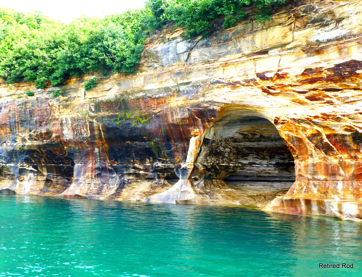
Why are we doing this???  This is where the main boat tours go out on Superior for Pictured Rocks....  Which we hope to do tomorrow or the next day...

Retired Rod


Monday, July 29, 2013

Whitefish Point / Great Lakes Shipwreck Museum

There is a lighthouse on Whitefish point about 40 miles back into the lake on the Superior side of Sault Ste Marie..  This light was first commissioned by President Lincoln...

It is the point on the Lake where the freighters turn almost South to go into the St Mary's river at its very end...  And it is the point where the Edmund Fitzgerald was attempting to make, in order to turn into the bay beyond and get out of the open lake gale on November 10, 1975...  But his radar had been knocked out by the storm....  Of course he never made it anyway, so that didn't matter...


It was overcast when we arrived before noon..  And the wind was blowing in off of the Lake....  You pay a museum fee of $13 for your unlimited access.. but it was extra to climb the light tower....   we didn't pay that..


The biggest attraction in the entire place is the bell from the ship raised in 1995 at a depth of 535 feet...


This is the fresnel lens from the light house..  It makes a small light visible for great distances...  It rotated, and in the days before electricity it rotated on a grandfather clock type mechanism that had to be wound by the keeper every few hours...


The gas mantle inside one of the smaller lens'


This one's on display inside the keepers house.


A wax replica of the keeper himself at his desk in the keepers house.  He seemed so real, it was eerie...


The big lake they call Gitchy Goomy... Key Gordon Lightfoot and his eerie ballad..    It was just 17 miles to the Northwest, the direction of this photo that the Edmund Fitzgerald sank....  Wikipedia


They had a building entirely dedicated to the EF and this model made from Lego's was its center piece...


The murals on the walls are very life like..


As we were getting ready to leave, there was one last building that showed a 15 minute documentary on the dives to the EF and the raising of the bell..  It was very emotional at the end as they rang the bell for each sailor aboard...  A second reproduction of the original bell was returned to the ship on the floor of the lake with all 29 men's names inscribed along with details of the sinking....  There wasn't many dry eyes in that little theater...

And as we emerged to the daylight out the back of the building, suddenly it was sunny outside.....


We went to lunch after that and on to a state park, but I will leave that for the next post...

Retired Rod